The harbour is the main reason that Hastings has come to fame.
It is currently located at the base of the East Cliff however
prior to the Great Storm of 1286 the harbour was located behind
the White Rock where Hastings Town Center is now. The current
harbour was originally an inlet with a shingle bank that protected
the ships from the prevailing south westerly winds.
Hastings has always been a fishing port, and had a large fleet
until the late 1300's when very high sea levels silted up the
old harbour, at the same time the French raided the town and
the Black Death also hit.
The sailors and vessels were a major part of Cinque Ports fleet
and in the late 1200's 21 vessels were provided but this was down
to 3 by the late 1300's
In the 15th century Hastings was only a fishing village, and
the council approached the Lord Warden of the Cinque Ports in 1562
for a grant to repair the pier (not the present one but a breakwater
used to protect the harbour). Unfortunately a major storm blew up and
badly damaged the pier before any work could take place.
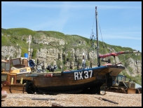
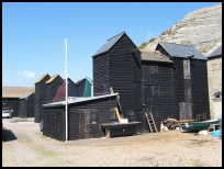
Nowadays the harbour still houses a fishing fleet, and fresh fish can
be bought at the net huts behind the ships. The net huts are black tarred
tall wooden buildings that, prior to nylon nets were used to dry the fleet's
nets.
Views
The harbour is very picturesque with it black tar coated ' net huts '
, used to hang the nets to dry before the advent of nylon.
Services
Map
Hastings Harbour is shown as the red symbol on the map.
Nearby Villages (click on symbol to see the village page)


 The harbour is the main reason that Hastings has come to fame.
It is currently located at the base of the East Cliff however
prior to the
The harbour is the main reason that Hastings has come to fame.
It is currently located at the base of the East Cliff however
prior to the 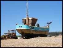 The harbour is very picturesque with it black tar coated ' net huts '
, used to hang the nets to dry before the advent of nylon.
The harbour is very picturesque with it black tar coated ' net huts '
, used to hang the nets to dry before the advent of nylon.